

 Illustration by Maia Grecco .
Walking on Water
Streams gushed freely through cities—until they were seen as a nuisance. Now, we need them back.
In the old house in Victoria where I used to live, there was a mysterious, soup-can-sized hole in one corner of the basement. Covered by a saucer-shaped metal lid, it descended through the cement floor to an indiscernible depth.
Most of the time I paid it no attention, but during heavy rains, a gurgling voice would call out from the dark cavity. The harder the rain, the more insistent the clamour, and if it poured for long enough, water would rise to where I could see light glinting off its surface when I lifted the lid to anxiously check the level. Although it only reached the top and spilled out into the room a couple of times during my twenty-seven years there, the boisterous monologue never let me forget about the possibility of flooding.
Last fall, my partner and I sold the place and moved to another part of the city. That two-storey house, built from old-growth Douglas fir in 1898, had been my home for nearly half my life and I’d put a lot of money and love into it over the years. Even though it was the right time to leave, letting go was hard.
I wanted the impossible—to bundle it all up and take it with me—but settled for gathering a few mementos, including an elegant porch post that we’d had to replace and some cherished plants from the garden. Also a photo of the ripples of colour that sunlight, glancing through a stained glass window, cast on the living room wall. And an audio recording I made while crouched next to the hole in the basement floor during a late summer shower just before we left. By then I finally knew the source of that watery discourse.
Fernwood, one of British Columbia’s oldest settler enclaves, is known for its counter-culture vibe, tree-lined streets and abundance of heritage buildings. My former house sits at the bottom of a dip in the area’s rolling terrain, so I always had to start in low gear when heading west or east on my bike. When I cycled north, however, I had gravity on my side, a topographical clue that took me years to register. From my front porch, I saw paved streets and sidewalks, lawns and gardens. What I didn’t see, and no one has seen in over 130 years, was the pond that once filled this broad depression.
The original Lkwungen’athun name for it is long lost. There’s also no record of what the early residents of Fort Victoria, who filled their water barrels at the pond, called it. Later, citizens who swam in the pond in summer and skated on it during winter cold snaps named it after Victoria’s first mayor, Thomas Harris. But in the late 1880s, Harris’s namesake ceased to exist. That was when city officials filled the pond and confined its outflow creek to a brick culvert buried three metres underground.
Their actions were part of a global effort to combat typhoid, cholera and other waterborne diseases by preventing people from treating water bodies as garbage tips and streams as open sewers. I don’t know how pervasive these waste disposal practices were in Victoria, but covering over ponds and creeks also served developers’ interests by creating more building sites. At the time, eliminating health hazards and facilitating urban expansion in one efficient move seemed progressive.
I had lived in Fernwood for at least a decade before I heard about Harris Pond, and even then its existence seemed more like fable than fact. Occasionally during conversations with neighbours about how wet our yards were in winter, or how vigorously trees grew on our properties, someone would mention the rumoured watering hole/swimming pool/skating rink, but no one could tell me its exact location. I didn’t realize that finding the answer to that question would reveal that the city I thought I knew so well was not quite as it seemed.
When you walk city streets, what lies beneath your feet? Concrete, yes, and rocks and soil, but that’s not all. Almost certainly there’s also water flowing down there. Brooks, streams, sometimes even full-grown rivers—gagged and bound and interred by urban infrastructure. You might not know those watercourses are there, but all over the world, activists are searching them out and working to bring them back to light and to life.
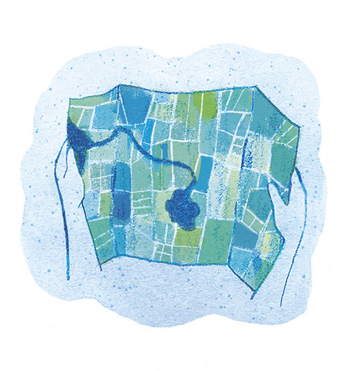
I was introduced to this idea by something called the Fernwood Community Green Map. It was part of a citywide a project guided by a University of Victoria geographer and carried out by community volunteers. In Fernwood, Dorothy Field, a visual artist, poet, former farmer and veteran environmental campaigner, led the map-making team. At first she wanted to produce a cartographic work of art and was particularly interested in recognizing the area’s first inhabitants—the Lekwungen, known today as the Esquimalt and Songhees Nations. But another member of the team soon piqued her curiosity about the water trickling below Fernwood’s modern surface.
I picked up a copy of the free map soon after it came out in 2015 and eagerly unfolded the stiff paper, which opened to a sheet the size of a placemat. On one side, archival photos, explanatory text and an 1863 city survey map offered a historical overview. On the reverse, a hand-drawn map showed current landmarks and the watery vestiges of the past. A blotch of blue ink superimposed on the contemporary street grid represented Harris Pond’s obliterated footprint.
One look at that blotch and I instantly understood why one of the tallest poplars in the city towered above my home and what that spectral voice in my basement had been rambling on about. For there was my house, perched right on the edge of the pond.
A thin blue line, dubbed Rock Bay Creek by the community mappers, snaked away from the pond, heading for the sea a few kilometres away. I traced its route along familiar streets where I had never suspected its underground existence, to Rock Bay, where it once formed a small cascade and tumbled into the ocean.
Sometime during the four years it took to research and create the community map, Field heard the word “daylighting”—that is, uncovering part or all of a concealed waterway. As a poet she loved the word and as an environmentalist she loved the concept. “So when we finally made the map,” she recalls, “like a fool I said, ‘We’d better daylight the creek.’” She now admits she “didn’t have a clue” about what that would entail, but with those bold words, Rock Bay Creek Revival was born.
Field, and our little creek, are part of a global phenomenon. When the hidden hydrology movement took off a couple of decades ago it was mostly driven by ecological and aesthetic considerations. Now, climate change has upped the ante. As droughts grow more common and record-breaking rainstorms make unprecedented demands on urban water systems, the need to reimagine our relationship with the streams and rivers we’ve forced underground is becoming critical. The most colossal example of that reimagining is South Korea’s restoration of the Cheonggyecheon River in downtown Seoul, which involved demolishing a four-lane elevated highway at a cost of roughly half a billion Canadian dollars. At the other end of the scale are small volunteer-led projects, like the one underway in my old neighbourhood in Victoria.
A few years ago I went on one of Field’s creek walks. As the group strolled along she drew our attention to the contours of the land, pointed out how water-loving poplars, cedars and willows revealed the creek’s covert course and told us about houses with hand pumps in their basements. At one intersection we paused by a storm drain and bent down to listen to the murmur of water. It hadn’t rained for days and the street was dry, but Rock Bay Creek was clearly alive down there in the dark, the invisible veins of our local watershed.
Of course, fully re-revealing the creek isn’t an option, with most of its path now covered by roads and houses. The only places where it might reasonably be returned to a more natural state are three pocket parks that the early developers left as green space because they were too swampy and prone to flooding. “We have to be very happy that they didn’t know how to build on wet spots a hundred years ago,” Field says. Now we have the opportunity to uncover short sections of the creek in those places and to establish rain gardens—small bowl-shaped areas that collect rainwater from roofs and driveways and divert it from the sewer system. These can help stave off the inundation of streets and basements during exceptionally wet weather.
So far, there’s no firm plan in Victoria to put the ideas for Rock Bay Creek into action. “It’s not impossible, but it’s pretty tough,” Fields says. “And now with Covid, it’s not going to happen right away, that’s for sure.” But she is heartened by any sign of support from the city. A recent budget document mentions daylighting, which she attributes to the realization that the city’s aging stormwater management system won’t be able to cope with the kind of rains that climate change has in store for us.
Even getting Rock Bay Creek back on the map is progress. Its sinuous inked line forms part of the blueprint that nature has given us. And the more clearly we can read that blueprint, the more likely we are to consult it as our cities confront a new era of environmental problems.
The chances of most buried urban watercourses ever seeing the sun again are infinitesimal. That’s partly due to our out-of-sight, out-of-mind mentality, but there are practical considerations, too. In addition to re-engineering subsurface sewers and stormwater drainage systems, daylighting often requires dismantling structures that have been built overtop.
The bigger and older the city, the more challenging the makeover. As Helen Mills, the founder of Toronto’s Lost Rivers Walks, says, “We’re not going to be digging up the Eaton Centre to get back Taddle Creek, or not any time soon.”
Mills was born in South Africa and moved to Canada in 1966. The fifteen-year-old immigrant didn’t care for her family’s first stopping point, Calgary, but when they relocated to Toronto three years later, it quickly felt like home.
Still, she was a newcomer, exploring a new territory. As she wandered through the city, she kept encountering landscape anomalies that simmered in her subconscious for years. Her first ah-ha moment came while studying physical geography at the University of Toronto. Reading an academic paper, she was brought up short by a description of a Toronto street with an abrupt bend that made no sense in a modern context, but had originally served to dodge the Taddle Creek ravine.
Though the ravine was filled in long ago, the street’s eccentric configuration remained, and remains, as silent evidence of its demise. Mills’s mind instantly leapt to a strangely curved alley that had always puzzled her and which she now saw was another manifestation of the city’s old river system.
Her epiphany left her eager to find out more about what had gone missing. Eventually she connected with a group of like-minded people. In the summer of 1994, Mills, along with a historian, a geologist and a retiree with an “encyclopedic knowledge” of the city’s obscured waterways, co-led a walk that followed the erstwhile course of Mud Creek. Much to Mills’s surprise, thirty-five people showed up for the event—a mix of environmentalists, history buffs and “curious and geographically literate types” who had already been thinking about underground pipes and vanished streams. “The sewer geeks…had their noses down every sewer grate along the route, looking at the sewer maps and figuring it all out,” Mills recalls. “It was an amazing experience.”
Within a year, Mills had launched Lost Rivers Walks, an organization now jointly run by the Toronto Green Community, the Toronto Field Naturalists and other community partners. Today, there are few Torontonians whose expertise exceeds hers. Name any creek and she can tell you its story and give you a detailed itinerary for tracing its path. Eleven-kilometre-long Mud Creek, she explains, “describes the arc of urbanization in the twentieth century and the late nineteenth century in a really interesting way” as it traverses the city from its source near the Downsview Airport to where it enters the Don River at the Don Valley Brick Works.
Lavender Creek, which rises in the area of Vaughan Road and Dufferin Street south of Eglinton Avenue, was “one of the most gorgeous creeks in its past,” she says. Now it’s “the most utterly trashed, devastated piece of water that you could dream up,” home to scrapyards, slaughterhouses and worse. Mills calls Lavender her “pet lumpenproletarian creek” because it has received less of the restoration funding that’s gone to projects in more affluent neighbourhoods. “There’s a really interesting social justice piece there,” she adds.
And then there’s Taddle Creek, whose “deep history,” preserved in a wealth of written descriptions, stories and photographs, makes it one of Mills’s favourites. She also considers it special because of its cameo appearance in a pond in Wychwood Park. Of all the Toronto Bay creeks that used to flow into Lake Ontario, this is the only spot where any of that water still surfaces.
Over the years, several proposals to daylight a segment of Taddle Creek on the University of Toronto campus have been made and rejected. One stumbling block is a problem encountered in many older cities: the complexity of dealing with combined sewers, which use the same pipe system to transport domestic sewage, industrial waste and rain and snow run-off.
“It’s not just like, ‘Oh, take this away and put back the pretty ravine please,’” Mills says. “There are very good reasons that we have sewers, and there’s people in Canada on reserves and other places who would love to have some of that sewer infrastructure.” On the other hand, she points out, our current standard approach to handling human “waste”—a term she deplores—is far from perfect.
Old-fashioned flushing requires huge energy inputs (one third of Toronto’s electricity bill is used to run its water system, according to Mills). It squanders nutrients that could be used as fertilizer. And it creates pollution when heavy rains overwhelm the system, dumping the excess water, along with raw sewage, into rivers, lakes or oceans. “Is the problem that the river is underground, or is the problem that the river is being subsumed into a [sewage management] system that is inherently out of balance?” Mills asks. “If you just think of it on that level, my response is we need heroic ecological engineering that goes beyond the mere daylighting of the rivers.”
When Mills first became enamoured with Toronto’s lost rivers, she “wanted to do environmental art and paint blue lines on the road and over the buildings and name the creeks and bring them to the surface of people’s awareness.” She still embraces both art and walking the land as ways to foster public appreciation, but her focus has shifted—she’s now urging a bigger recognition that “every inch of the landscape is part of the water cycle.”
These days she’s actively involved in a project called RAINscapeTO, which focuses on installing rain gardens. “Any place that we put a rain garden that soaks water into the ground rather than dumping it into a sewer is a place where we’re actually helping lost rivers and the water cycle,” Mills says.
Landscape architect and photographer Michael Cook has also spent years contemplating the pipes and culverts that swallowed up most of Toronto’s creeks and rivers. But while most hidden hydrology enthusiasts are content to track culverted watercourses at street level, Cook—like other members of the secretive subculture of “drainers”—prefers to descend into the dark, dripping labyrinth and explore it firsthand. His stunning photos of urban subscapes are both an artistic expression of his passion and an attempt to get the rest of us thinking about what’s going on under our feet.
As Cook writes on his website, Vanishing Point, “One of the reasons that it has been so difficult to get traction around most water issues in our North American cities is that the infrastructure has been allowed to become completely invisible. Everything is in a black box, and as a result we imagine this infrastructure as a ubiquitous network that just works. The problem that we are coming to grips with is that everything doesn’t just work—there were massive tradeoffs and damages in the way that we chose to service our cities.”
Public consciousness of the environmental costs of large-scale water engineering projects has been growing for decades, fuelled by books like Marc Reisner’s American classic, Cadillac Desert, and Sarah Cox’s Breaching the Peace, a recently published call to action against BC’s Site C Dam. But our understanding of the impact of human engineering on metropolitan water systems has not kept pace. The very first thing we need to grasp is how ubiquitous the culverting of streams and rivers has been. From ancient Athens to present-day São Paulo and every urbanized point in between, building cities almost always involves forcing surface water underground.
These days, daylighting doesn’t just undo some of the damage—rebuilding biodiversity and giving city-dwellers back the pleasure of seeing and hearing water in motion—it’s also a way of coping with climate change. Free-flowing water provides passive cooling, and natural stream channels with permeable banks increase stormwater management capacity.
Every so often Mother Nature sends out a reminder about the shortcomings of our water infrastructure. In Dartmouth in 1971, it was an unexpected deluge overwhelming the city’s drainage system and filling the streets with waist-high water that carried off anything that floated, including bowling pins swept out the door of a flooded bowling alley. In recent years, in many cities, it’s masses of supposedly flushable disinfectant wipes combining with grease to form so-called “fatbergs” that clog the arteries of sewage systems.
But despite the big, and growing, problems, most people only begin to grasp their relationship to the water cycle when this abstraction is made tangible. “I think our connection with water is very visceral,” Mills says.
That’s why she likes to get people out on foot, looking for clues like elevation changes or a street that dead-ends oddly where a now-nonexistent ravine once blocked its way. She delights in seeing others’ ah-ha moments. “When one comes to that sudden recognition of, ‘Oh my God, these three fragments of park are part of a system and it’s gathering water from the high places to the low places and it’s the life-support system for this mosaic of amazing life, past, present and future,’ that is a profound discovery.”

The majority of Toronto’s streams may be destined to remain in lockdown, but on the opposite side of the country from me, in Nova Scotia, the city of Dartmouth is in the middle of Canada’s largest daylighting project to date. Like most disappeared watercourses, the Sawmill River was banished to the underworld in the name of public health and safety. It’s a story urban-planner-turned-city-councillor Sam Austin knows well.
“Where it all began was 1971,” Austin explains. “Hurricane Beth roars through downtown Dartmouth. Dumps a pile of rain. Caused all sorts of flooding. And in the aftermath of the hurricane, the city took the Sawmill River and put it in a pipe underground. That’s how you dealt with stormwater in the 1970s.”
The Sawmill is a short river with a long history. For thousands of years, it was an important canoe route for the Mi’kmaq—a half-kilometre connector between the ocean and a chain of inland lakes. They called it Punmakati, in honour of the punamu (in English, the Atlantic tomcod), one of several fish species they harvested from its waters. In the 1700s, European settlers evicted the Mi’kmaq from their waterside homes, claimed the river for their own purposes and renamed it for the sawmill that harnessed its energy and churned out lumber to build their new towns. As that hydropower continued to support a variety of industrial activities over the next two centuries, the waterway became more and more degraded. By the time of the post-hurricane decision to bury the river, the only people who lamented its loss may have been the undiscerning kids who still played in it.
Fast-forward thirty years, however, and that 1970s kind of thinking about how to handle stormwater was showing its age, as was the corrugated steel culvert that contained the river. By the early 2000s, climate change was also cranking up the pressure to approach things differently.
“The pipe was old and failing,” Austin says, “but it was also undersized. If a similar event to Hurricane Beth, a similar massive rainfall, were to hit Dartmouth, the existing pipe would not be able to protect Dartmouth adequately [and] we would have flooding again. That’s because, not only are storms getting worse, but also since the 1970s, the whole drainage basin around the river and the lakes in Dartmouth has seen a whole lot more development.” As a result, paved roads and subdivisions now cover much of the forested land that once absorbed rainfall and slowed down runoff.
Replacing the pipe with an alternative that could carry larger volumes of stormwater “was a have-to project,” Austin says. “The only question, really, was are we going to daylight [the river] or not.”
Community support for the daylighting option was strong from the start, with advocates lining up behind the Ecology Action Centre, based just across the harbour in Halifax. The greatest opposition came from budget-conscious government bureaucrats and wary water utility officials. In the end though, it was the most silent stakeholders that decided the matter. No matter how the original pipe was replaced, the Department of Fisheries and Oceans had decreed that the new version could not present an obstacle to alewives—small, herring-like fish better known to Nova Scotians as gaspereau—migrating between Halifax Harbour and their inland spawning grounds. And as Austin notes, “fish don’t like to swim through dark tunnels.”
“You could have still done fish passage without daylighting,” he says, by installing either artificial lighting or intermittent grates to let in some natural light from overhead. “But it probably would have ended up costing more. Bringing the river up above ground, from a fish passage perspective, was actually the most effective, most affordable option.”
Legal imperatives and fiscal logic aren’t always enough to move daylighting projects forward. In this case, it took years to convince the decision makers that there was sufficient public support for resurrecting the Sawmill River. One of the key actions in the prolonged campaign was a Human River Walk held in April 2015. Organized by the Ecology Action Centre, the event drew more than two hundred participants, most of them dressed in blue to embody the river. They followed the path of the underground pipe, bearing long, blue banners that waved in the breeze and holding aloft little paper fish on sticks. While the hand-coloured cut-outs were intended to symbolize migrating gaspereau, they also represented other species that had lost access to the river, including Atlantic tomcod, Atlantic salmon, American eels and sea run brook trout.
Austin was one of the walkers carrying a paper fish that day. At the time, he was an urban planner who saw the proposed Sawmill River project as a once-in-a-generation chance to right past wrongs. Less than a year later he was sitting on Dartmouth city council, helping to finalize plans for the daylighting scheme. Restoring the Sawmill was a major inspiration for Austin’s run at political office. “As human beings we are just hard-wired to want to congregate by water,” he says, “so to bring back a running river through downtown Dartmouth—what an opportunity.”
And the Department of Fisheries and Oceans estimates there could be “several hundred thousand gaspereau that migrate up the Sawmill River once the whole project is done,” he says, moving from there out into the entire nexus of rivers and lakes and re-establishing a food chain that used to link marine and freshwater ecosystems. “So from an environmental perspective, the payoff is potentially huge.”
The first phase of the project was built in 2018 at a cost of $8.9 million. The river still ducks under one street, but most of the 330-metre stretch, previously covered by municipal park space and part of a condo building’s lawn, is now open to the light and air. The showpiece is a new pedestrian bridge which spans the river at Sullivan’s Pond and overlooks a state-of-the-art fish ladder that will, once the connection to the harbour is complete, give fish a boost as they head upstream.
With the water rippling between faux-stone walls made from pressed concrete, this revamped upper segment of the river has an attractive but distinctly engineered appearance—the concrete was necessary to allow the channel to be robust enough to deal with run-off from major storms. Austin says he hopes the other half of the project will include a section of more natural reconstruction “where the river can really be free.”
That second phase, which will carry on down to the harbour, won’t be done until 2022 at the earliest. It’s technically more complicated because it involves digging up and redesigning one of the busiest intersections in Dartmouth, and some of the details are yet to be worked out, but the biggest issue has been resolved. “There isn’t a debate anymore about whether the river will come up above ground or not,” Austin says. “That’s settled.”
Closer to me, another iconic fish species has made a comeback in a Metro Vancouver waterway, thanks in part to daylighting. I only learned about Still Creek this spring—through videographer Marina Dodis’s new documentary short, The Return—but people have been calling for its restoration since the mid-1980s.
Although this seventeen-kilometre stream enjoys relative freedom as it flows east out of Burnaby Lake Regional Park, then through an undeveloped corridor of the famously huge suburb, its lower reaches have not fared so well. On the Vancouver side of the municipal boundary, nearly three quarters of Still Creek’s length is pipe-bound and much of the rest is channelled through narrow concrete flumes. In both cities, it traverses extensive industrial zones. Until recently, a toxic mix of chemicals, sewage and garbage made it one of the region’s most polluted waterways.
Like most of Vancouver’s forty-seven original salmon-bearing streams, Still Creek long ago ceased to be habitable for fish. Nonetheless, as one of only two that retained any above-ground presence, it was a prime candidate for rehabilitation. The most pragmatic proponents focused on how it would increase stormwater capacity and urban beautification, while the dreamers conjured up visions of salmon muscling their way upstream to restart the ancient cycle of life.
In 2002, after decades of discussion, Vancouver city council finally adopted a ten-year action plan that included naturalizing sections of the channel and banks and uncovering one culverted stretch. A decade later, chum salmon spawned in Still Creek for the first time in eighty years and were back every fall for a while. In Dodis’s words, “It was miraculous.” The salmon have been absent for the last three, with people anxiously trying to figure out if there are other changes the city needs to make, or maintenance it must rigorously keep up, to make the miracle permanent.

On the Lost Rivers website, there’s an interactive feature called the Disappearing Rivers Slider, which shows the last year that each of Toronto’s rivers and creeks appeared on a map. I go back to it again and again, fascinated by this digital variation of the community map that first made me think about this in Fernwood. With the slider set to the earliest date, 1802, multi-coloured skeins angle across the land, merging with their companions or spilling directly into Lake Ontario. As I drag the slider to the left and advance the calendar, they start to dematerialize, one colour at a time. The spaces between them grow wider, the severed sections more numerous. By 1950, the slider’s endpoint, the smaller creeks are nearly all gone and large swaths of the GTA have no waterways of any size flowing through them.
I wonder what it was like to witness that kind of environmental overprinting in person. One summer you’re splashing around in Harris Pond with your friends. The next you’re walking over its grave. Do you grieve or do you shrug? Did people mourn the loss of local streams and all that went with them? Did they miss the rhythms of running water, the frogs’ spring chorus, the flowers, the birds? None of these places was pristine by the time they were extinguished, but that doesn’t mean they weren’t appreciated or even loved. Yet we forgot about them.
“I think we just fell asleep to water,” Field once said to me. Her sense of urgency about unearthing at least part of Rock Bay Creek, under my old neighbourhood, is partly fuelled by a compulsion to reverse that amnesia. For all such streams, in all cities, she says, “when we paved it all over, we kind of paved our brains.”
Now, as I walk around my new neighbourhood, I listen for the voices of ghost streams calling up from the storm drains and I scan the terrain, trying to decipher original stream paths. Some of them lead to a pond that’s not far from my house, a half-wild place surrounded by unkempt shrubbery and haphazard trees, where ducks paddle and turtles sun themselves on floating logs. Gazing across its sky-reflecting water, I often wonder whether the vanished pond I used to live beside looked something like this.
Frances Backhouse is a freelance writer who now lives near the Pacific and has previously lived in watersheds connected to Canada’s other two oceans. Her writing focuses on environmental issues and history. Her latest book is Once They Were Hats: In Search of the Mighty Beaver.