

 Photographs by Jimmy Thomson.
Paradise Lost
Making a park isn’t as simple as drawing lines on a map. Jimmy Thomson on the politics, petroleum and polar bears that have shaped one Arctic conservation area thirty years in the making.
ON A COLD SEPTEMBER MORNING, standing on the bridge of the small expedition cruise ship Akademik Ioffe, I watched the impossible: a pod of pilot whales swimming nearly a thousand kilometres north of their known range. The north coast of Baffin Island and the entrance to the historic Northwest Passage were appearing in the distance, and the pod was travelling back south, possibly feeding on the capelin and squid that have been moving towards the pole as the ocean warms.
Regardless of what allowed the pilot whales to be there, I was happy to see them. The first week of the trip had been lacking in marine mammals, and in my role as one of the cruise ship’s onboard naturalists, it was easier to answer the guests when they asked, “What’s that whale?” than “When will we see whales?” In my seven seasons on expedition cruises throughout the Arctic and Antarctica, I’d met dozens of eager Canadians, Americans and Europeans who had paid up to $15,000 in the hopes of seeing all manner of wildlife and natural phenomena; whales never failed to elicit a reaction.
Tourists are now visiting the Arctic in greater and greater numbers, and with a new urgency. In Sir John Franklin’s time, there was the unbridled optimism and pride of Industrial Revolution-era England: the north was a mystery to be solved and there was nature to conquer. Today there is a sense of sadness that perhaps nature has been conquered, or at least wounded. The mystery is largely gone, and travellers talk of experiencing something before it disappears forever.
We know now that the Arctic is not the isolated frozen kingdom that we once imagined it to be. Instead, it is a fragile physical system that has the potential to kick back and wreak havoc on southern climates. It is also an untapped bounty of economic potential. The warming ocean that brought the pilot whales so far north is simultaneously pushing the sea ice back, inviting both the spectre of the fishing trawlers that have devastated the rest of the world, as well as the towering oil rigs that make headlines each year when they fail and spew black sludge from the deep. And, where the ice remains, icebreakers bearing cargo will ride atop it and crash through, scattering the wildlife and fragmenting their frozen habitats.
For all these reasons and more, governments are now bickering over imaginary lines. At some point that morning our ship crossed one such line. Nobody onboard noticed. It marked the entrance to a place known in Canadian government press releases as the “Serengeti of the Arctic.” The Inuit call it Tallurutiup Tariunga. And, one day soon, it will be known as the Lancaster Sound National Marine Conservation Area (NMCA), a 40,000-square-kilometre ecological marvel that is still being planned more than thirty years after it was first discussed.
A new designation created in 2002, an NMCA is almost like a national park—it is the government’s way of saying that a place is fragile enough to protect, but too economically important to protect too much. The NMCA designation recognizes that the people who live in the area—who have lived there for generations—survive by sustaining themselves off of the land and sea. It also recognizes that there is money to be made.
The Lancaster Sound NMCA will protect against certain kinds of human activities: a ban on oil drilling will take effect within its boundaries. But, knowing this, the NMCA borders—drawn and redrawn again over the decades due to economic and political pressures—have been deliberately created to exclude prime oil potential in the area, leaving out thousands of square kilometres on its eastern margin that mirrors contested Shell permits.
While oil drilling, waste dumping and seafloor mining won’t be permitted inside the protected area, fishing and hunting will be. And one of the world’s most northerly iron mines, just south of the future NMCA, is coming online now and will eventually spit out enough rock to ship tonnes of iron ore through it every other day. Maybe most importantly, the NMCA’s location marks the entrance to the fabled—and internationally contested—Northwest Passage, which is expected to become one of the most important shipping routes on the planet.
Currents connecting Baffin Bay with Lancaster Sound sweep right through the oil leases outside the conservation area. Like the pilot whales I saw, birds, fish and bears pay little heed to imaginary borders; the same can be said for oil spills and pollution. But by being there, the animals act as justification for the government’s attempts to balance conflicting interests while creating the Lancaster Sound NMCA. In the end, the park is not so much about protecting wildlife as it is about staking a claim to one of the last great contested spots on the map.
"NORTH” MEANS DIFFERENT THINGS to different people. For Americans, it often means Canada. In Toronto, it can refer to Sudbury, or, for those with a broader perspective, maybe Hudson Bay. But to understand where Lancaster Sound is, head past the bay until you reach the place where, come December, the sun no longer rises over the horizon. You’ve reached the Arctic Circle; keep going. Nine hundred kilometres later and you are there: Lancaster Sound and the opening of the Northwest Passage. It is as far north from Toronto as Calgary is from Guadalajara, Mexico.
It was this view from elsewhere that gave the Northwest Passage its name: it may be northwest of the European powers that spent decades trying to discover it, but relative to most of Canada, the passage is actually north and northeast. The same perspective continued to apply until the latter part of the twentieth century, when the Inuit and Innu began to negotiate land claims in the Arctic. Nunavut arose out of this process as a territory belonging to the Inuit in recognition of their presence there for a millennium.
While the Inuit have had success within Canada in gaining sovereignty over their Arctic home, Canada has had less success proving sovereignty over its Arctic waters internationally. To this day, most of the world—including the European Union, Russia and the United States—does not recognize Canada’s claim to the Northwest Passage, which includes all of Lancaster Sound. In waters that Canada calls its own, only the international law of the sea applies, meaning nobody needs our government’s permission to enter. While it may be riddled with hazardous sea ice today, the Northwest Passage is expected to become useful for international shipping in the near future, and the eighty kilometres spanning Devon Island to the north and Baffin Island to the south means that other countries argue there is international water in the middle. Furthermore, the Northwest Passage connects two separate areas of open ocean, meaning it can be considered an international strait, available to vessels from any country. There’s more to it, even, than that: why would other countries recognize the area as Canadian when Canadian governments have done so little to protect it?
Beefing up environmental protection in order to claim sovereignty over a stretch of water is a proven strategy. The Torres Strait, a contested area between Australia and Papua New Guinea, was protected in 1985 by both countries as a shared special management zone in a bid to settle a sovereignty dispute. In the Russian Arctic, the Wrangel Island Reserve was created and expanded at the eastern entrance to the Northern Sea Route, strengthening Russia’s control over the valuable shipping lane. Canada has also used environmental protection for this purpose in the past. In 1985, Pierre Trudeau’s Arctic Waters Pollution Prevention Act extended the northern zone of Canadian control eight times farther into the Arctic Ocean than it had been before.
“National parks do not just simply safeguard nature: instead, they are actually complex products of statecraft, domestic policy and even foreign policy,” writes Mia Bennett, a UCLA geographer who studied the Lancaster Sound NMCA and the Wrangel Island Reserve for an Arctic Yearbook article. She sees the creation of these protected areas as “performative sovereignty, outwardly demonstrating state power to audiences ranging from their own citizens to the international community.”
Uncontested sovereignty over these Arctic waters would mark a huge geopolitical win for Canada. It would mean ensuring control, for generations to come, over potentially lucrative fishing and mineral rights for a huge swath of territory. At the eastern end of the Northwest Passage is a line the Canadian government would like to will into existence, and that’s where the future Lancaster Sound NMCA comes into play.
IN THE EARLY 1980S, Murray McComb, a Parks Canada senior planner who would later become an agency director, set his sights on Lancaster Sound. McComb envisioned an integrated marine and terrestrial park that would span the entrance to the Northwest Passage.
Cohesion between land and water protection was central to McComb’s idea. “When you look at maps of northern Canada, it kind of struck us as a bit bizarre—you’d see everything that was water would be blue,” he says, adding that the reality is markedly different. “Eighty percent of the year you might as well have coloured it all white because of the ice. It’s really, even more so than the rest of Canada, one integrated environment.”
McComb wanted the park to encompass part of the North Water, an unimaginably rich ecosystem to the east of Lancaster Sound. With the sea frozen most of the year, the North Water is one of the few places in the Canadian Arctic that is reliably ice-free. It is where seabirds can find their prey and marine mammals can breathe the air all winter long.
An integrated park in Lancaster Sound, McComb says, would have been a chance to “show the world” that Canada was conserving its Arctic environment—meaning other countries would be more likely to acknowledge Canada’s sovereignty over it. But his vision required the permission and cooperation of the local Inuit, whose livelihood could be threatened by a protected area on their doorstep.
McComb began visiting with the approximately 2,300 Inuit who live in Arctic Bay and Pond Inlet to discuss his plan. The locals he met with were primarily concerned about two things: shipping and the polar bear hunt. They were worried that with a marine park in place, the rich Americans who flew up to bag the world’s largest land predator would take their money elsewhere, and with rumours that oil exploration was going well in their backyard, they wanted control over any commercial traffic in the area.
One March evening in the early 1980s, well before Nunavut was negotiated as a territory, McComb arrived in Pond Inlet for a series of public meetings that would determine what his proposed park would look like and what it would mean for the local citizens. Adults, elders and children had come from as far away as Arctic Bay (a 240-kilometre journey by snowmobile); McComb was also joined by Bob Gamble, a public consultation expert from Yellowknife.
The meeting was long. Every word needed to be translated from English to Inuktitut and back again. Eventually, though, it became clear that the people whose livelihood depended on access to their land were having trouble accepting some of what a park would entail—especially where it concerned hunting. “They asked Bob and I to please leave the room and go grab a coffee somewhere,” McComb says.
The two visitors wandered out into the darkness and walked around the tiny hamlet for a couple of hours, waiting to hear whether their park had a chance. “When they called us back at some later point in the evening, they just said, ‘We’ve decided we don’t want to talk about the marine component anymore. We’re not interested in that.’”
McComb returned to Ottawa. Without local Inuit support, he was forced to abandon the marine protection and pursue a 22,200-square-kilometre terrestrial park. “We were disappointed, but optimistic,” he recalls. Knowing that asserting sovereignty was a good part of the reason the government was interested in creating the park, he had faith that the marine component would arrive eventually.
It wasn’t until 2001 that McComb’s terrestrial park, dubbed Sirmilik National Park, was created on Bylot Island and north Baffin Island. Even Sirmilik had required more concessions. The Mary River mine site, soon to become one of the northernmost iron mines in the world, was once within the park’s boundary. That changed as soon as then-titled Indian and Northern Affairs Canada saw the site’s resource potential. “[When the resources were found] there was just absolutely no way that that land was going to be part of a national park,” McComb says.
The marine protection of Lancaster Sound is taking much longer to secure. A form of environmental protection that attempts to strike a balance between human use and nature wasn’t even an option until 2002, when the National Marine Conservation Areas Act was signed into law. And, as many environmentalists and local residents discovered, attempting to strike a balance between local economies and the environment creates a new set of difficulties.

ATUAT SHOULDICE, THE INUIT GUIDE who was onboard the Akademik Ioffe, is an expert hunter with the kind of wealth of traditional knowledge that comes only from countless hours spent on the land with relatives, stalking animals and carving up their meat. Shouldice and I shared a cabin, which quickly took on the distinct odour of the smoked caribou he stored above the closet.
Now a resource management officer with Indigenous and Northern Affairs Canada, Shouldice shot his first polar bear on Baffin Island in March of 2014. It was a young male, about eight feet long; his mother sewed the hide into a warm pair of pants and he shared the meat around the community. “Your first catch of any animal, you give the whole thing away,” he says. “You always remember your first one.” And the pants will do more than just keep him warm during next winter’s hunting season: to Shouldice, they’re a badge of honour. “You’re really proud when you wear your own bear pants,” he says. “It kind of symbolizes you as a good hunter.”
On the morning when I reach Shouldice over the phone in Rankin Inlet, he sounds rushed; he’s helping his friend’s kids get ready for their first caribou hunt. “They’re from Iqaluit, but because of the moratorium they can’t catch one there,” he says. Not being able to hunt, for them, meant a separation from their father and the traditions he learned from his own father. Catching a caribou will help them reconnect with that part of their heritage. And, just like Shouldice’s first polar bear kill, the boys will share everything they catch with the community.
When I ask Shouldice how he would feel if he could no longer hunt, he grows quiet, as though considering which arm he would rather lose. “I know for myself if I don’t eat traditional food I get depressed,” he says. “I feel like something’s missing.”
Not all northern hunters have wholeheartedly accepted the idea of a wage economy—especially when that involves trading away the habitat on which their traditional food depends. Even while some residents of Arctic Bay and Pond Inlet will head to the Mary River mine for work, many will return to the land to catch the country food that has sustained humans in the north for millennia.
More than diet and tradition, hunting is often a necessity for simply getting by in the northern economy. Shouldice thinks back to his time in Repulse Bay, where the narwhal hunt is a major annual event. Just one catch provides meat as well as a valuable tusk. “That one time a year, to get a large tusk in your household would mean enough fuel and a brand new snowmobile for the upcoming season,” he says. “They sell the tusks as a source of income, but also the meat provides food for your family. You can spend easily $500 to $700 a week on groceries.” Arctic communities also make money from other people hunting: in Pond Inlet, about $100,000 a year is brought in by trophy hunts. In Arctic Bay, it’s closer to $120,000.
Inuit hunting is not nearly the same as oil drilling in the scope of its impact on the environment. But Jacques Sirois, a former Canadian Wildlife Service biologist who has spent the last thirteen years working as a naturalist on expedition cruise ships, says that if the government is going to call the Lancaster Sound NMCA a protected area, there should at least be some protection against harvesting full-stop. No strict off-limits areas have yet been announced, but the National Marine Conservation Areas Act could require that the final NMCA include some zones of higher protection, excluded from the hunting, fishing and shipping that will be permitted in the rest of the area. “I would hope if we create a park, that some areas would be off-limits to everybody, including Inuit hunters,” Sirois says. After a pause, he adds, “I know this would not be a very popular conversation over there.”
MAKING A PARK ISN’T AS SIMPLE AS picking out the best places to protect and drawing lines around them—that’s easy. What happens next is a political process that results in a shrinking, morphing shape, subjected to the demands of conservation groups, hunting associations, mining companies, residents, governments and other stakeholders. The Lancaster Sound NMCA is no different; in fact, it can be seen as a case study in compromise.
Following the rejection of McComb’s original plan, the marine park went on the back burner until 2007, when it reappeared in the Conservative budget. By 2010, the National Post was praising then-Environment Minister John Baird’s assertion that the federal government was “prepared to give up potential oil riches in Lancaster Sound to protect the Arctic waters’ ‘amazing and inspiring’ ecology.”
This was true, in a sense. There is resource potential in Lancaster Sound—billions of barrels of oil and trillions of cubic feet of natural gas—and the ecology is indeed amazing and inspiring. But, taking into account the industry’s concerns, the biggest oil leases in the area were deliberately left out of the proposed protected zone.
“Looking at the map of Lancaster Sound [NCMA], I just find that this is an amazingly small area,” says Sirois. “Right off the bat, I would triple this. Why not put all of the North Water into a marine park?”
The answer to that question is simple: this unprotected area includes more than 8,000 square kilometres of Shell oil permits, which mirrors the boundary where Lancaster Sound meets Baffin Bay. (After the World Wildlife Fund challenged these leases in February 2016, the government upheld them. However, Shell Canada released its claim on the leases in a June announcement.) This means that in the North Water—just outside the NMCA boundary—offshore drilling, with all its inherent hazards, could one day begin.
This compromise between economic interests and the environment is embodied in the Mineral, Energy and Resource Assessment (MERA), which is built into the early stages of all northern park developments. The MERA ensures that no valuable extraction opportunities are passed over in the rush to protect wilderness. When resources are discovered, the environment often takes a back seat. “It’s very difficult, particularly in today’s environment, to put a [park] proposal on top of gas and oil rights and expect to get even to the starting block,” explains McComb.
That’s not to say everyone in the agency is happy about kowtowing to resource extraction opportunities. “Often we had some of our hardest discussions—almost battles—with our colleagues in other federal departments before we could even get out the door with a boundary,” says McComb. “It may look like we’re giving up too much, but either you give up something or you give up the proposal. That’s a reality.”
The act of trading off conservation for resource development presents the risk of disaster to any newly protected area, but especially one in a marine environment. While the dominant movement of water drains the waters of the Arctic Peninsula into Baffin Bay, the currents of Lancaster Sound are not so simple. Swirling in a giant eddy, a strong counterclockwise current penetrates one hundred kilometres into Lancaster Sound. It crosses right over Shell’s leases, muddling both the waters and the very notion of keeping the outside separate from the inside of the future Lancaster Sound NMCA.
NINE YEARS BEFORE THE EXXON VALDEZ SPILL, Canadian government and industry-funded scientists grew curious about how spilled oil would behave in the Arctic. No longer content with lab results, scientists decided that “a small sacrifice” was warranted, and dreamed up the Baffin Island Oil Spill Project (BIOS). They chose a spot just southwest of Pond Inlet and dumped seventy-five drums of oil in the water in the late summer of 1981. Then they watched for a few years as the oil was swept away, marvelling that most of it was diffused by the waves and tides. This perfect scenario convinced the scientists that there were “no strong ecological reasons for the cleanup of oil stranded on Arctic shorelines.” However, a follow-up study later discovered samples of oil in the water that remained “essentially unaltered” despite twenty years of exposure to the elements.
Later, the Exxon Valdez spill and the Deepwater Horizon blowout occurred. Both are among the largest man-made disasters ever; neither occurred in the icy Arctic. Up here, brand new challenges await cleanup crews. In 2010, oil spill response expert Ron Bowden testified before a Senate committee to lay out the potential challenges: “You can’t lay boom around ice; you can’t recover oil from the surface because it’s hampered by the ice or under the ice.” Bleakly, and in contrast to the rosy outlook of the BIOS scientists, he concluded, “There is really no solution or method today that we’re aware of that can actually recover oil from the Arctic.”
In a National Energy Board filing, Imperial Oil suggested that it may be able to clean up to 40 percent of oil spilled in open water during the summer. Shell, meanwhile, contends that burning oil on the surface could remove “85 to 95 percent in most situations.” This assertion is directly contradicted by what happened during the Deepwater Horizon blowout: despite near-perfect conditions, only 5 percent of the oil was successfully burned. Add ice to the mix, and an Arctic oil spill could be much worse.
In theory, ice could help protect Lancaster Sound in the event of an oil spill, since the general movement of ice would push the oil away from the NMCA and into Baffin Bay. But this ideal scenario would only be possible if the spill occurred in the winter. And if the cleanup crews were not delayed in reaching the site. And if they were adept at working in round-the-clock darkness. And if the weather remained calm.
If a spill occurred in the summer, a westerly wind could be the only thing preventing oil from bleeding into the protected area. Otherwise, the Lancaster Sound NMCA—the so-called Serengeti of the Arctic—would be tainted for years, just like Alaska’s Prince William Sound after the 1989 Exxon Valdez spill, where oil is still present and fading at less than 4 percent each year.
Compounding this reality is the fact that Canada is simply not prepared for an oil spill in the north. There isn’t a single place in the region that can act as a base for the Coast Guard ships needed to respond to a disaster; in fact, Canada’s Arctic icebreakers are based in Vancouver, Quebec City and St. John’s, Newfoundland.
An attempt to fix the problem by building the first Arctic deep-water port around the corner from Pond Inlet in Nanisivik has been an exercise in demonstrating the logistical nightmare of working so far north. The port was announced by the Harper government in 2007 and was meant to be operational by 2015. Today, the facility remains under construction, aiming for a 2018 completion date. Its scope has also been drastically scaled back. Essentially, it will act as a summer-only gas station for ships.
STILL AND COLD, shining like an enormous quartz pebble, an iceberg the size of a five-storey apartment building sat, grounded, on the gravel bottom extending from the shore of Pond Inlet. Slowly melting in the frozen water, turning over as its centre of gravity shifted, the ice had likely spent two years drifting along the Greenland Current after calving off a glacier on the island’s northwest coast. Arriving at the mouth of Lancaster Sound, perhaps even crossing over top of Shell oil leases, it would have been swept in by the currents and carried over the line of the future Lancaster Sound NMCA.
With the Akademik Ioffe anchored nearby, a barely audible crackling emanated from inside the ice, then coalesced all at once—a gunshot—and half the ice, frozen for thousands of years, broke away to spread out into the water as a snapping, clinking fan of Greenlandic snowfall. Bereft of the mass, the iceberg rolled in the water and lay quiet once more.
Many of the passengers lined up against the rail, snapping pictures of the now-jagged hulk. Meanwhile, Carey Elverum, a Parks Canada project manager, stepped onboard the ship to tell them about the Lancaster Sound NMCA proposal.
More than thirty years after McComb had started working on protecting Lancaster Sound, the machinery of the federal government was still grinding along. A new generation of Parks Canada officials had taken up the cause, and Elverum was based in Pond Inlet full-time, managing community consultations.
An hour after his arrival on the Ioffe, Elverum stood at the front of the low-ceilinged presentation room on the lowest deck as the audience, unaware of the distinction between a park and a conservation area, hurled questions at him. “What use is a park with fishing and hunting?” asked one passenger. “How are you going to stop the Japanese whaling fleet from coming here?” demanded another. Like me, the passengers were from the south, where food comes from stores and whales live in aquaria.
Elverum’s presentation, consisting of jargon-ridden, detail-sparse Powerpoint slides about sustainable harvesting and balancing ecology and the economy, had taken about twenty minutes. But Elverum was just the messenger, sent to manage expectations on behalf of a bureaucracy situated three thousand kilometres south in Ottawa. Relief softened his face as he stepped carefully down the gangway to the waiting Zodiac, which would return him to his office. Parks Canada must have known that without the marine mammal hunting and fishing that will be permitted in the NMCA, the proposal would be doomed to another rejection by the locals. This time pushback would have come from the Qikiqtani Inuit Association—the powerful local group that fights for Inuit rights in the north—in an echo of the way that McComb’s initial pitch for an integrated terrestrial and marine park was rejected thirty years earlier.
That evening, I imagined that Elverum dutifully wrote down what Parks Canada would characterize as “stakeholder feedback”; really, it had been a merciless haranguing by southerners shocked at the pragmatism of what they had imagined to be a righteous guardian of the Canadian wilderness. A stalwart protector of the wild may be how Parks Canada imagines itself—and how many Canadians think of it, too—but the reality is much more nuanced. The agency is hamstrung by legislation, politics, budgets and practicality, and the result is parks whose form and function tell a much different story than the one Canadians tell themselves.
PASSENGERS VISITING THE ARCTIC aboard expedition ships like the Ioffe tend to come with experience travelling all over the world. They’ve seen ancient civilizations, thriving cities, user-friendly jungles, and now, finally, want to walk amongst the few truly untouched places left on Earth. Of course, this is not entirely reality: humans have occupied what is now the Canadian Arctic for millennia, and they’ve left their mark. The local communities’ understanding of the Arctic was what eventually allowed Europeans to safely traverse what they called the Northwest Passage in the nineteenth century; today, the local Inuit communities’ longstanding presence and widespread use of the Arctic is now considered one of Canada’s best claims on Arctic sovereignty.
In ten years, when cruise ship passengers arrive in Lancaster Sound, they may think they are seeing an unspoiled wilderness, but what will really exist is an intensively altered landscape, just as it is today. Whale populations will endure Inuit hunts as they recover from the devastation of the industrial whaling era, and polar bears will continue to be harvested by local hunters and their foreign guests. Fish will be exploited with ruthless efficiency. The impacts will be visible only in what is missing: the whales that were never born, the fish that no longer feed the seals and birds, the polar bears killed by habitat loss and starvation.
That future for Lancaster Sound is all but assured. The government, unwilling to rescind Shell’s oil leases in the area, appears intent on allowing drilling. Mining will continue, on schedule. All the while, the “Serengeti of the Arctic” will continue to make headlines as a natural refuge unspoiled by humans. That tension between use, conservation and political posturing underpins the entire park planning process, but will remain mostly shielded from public eyes.
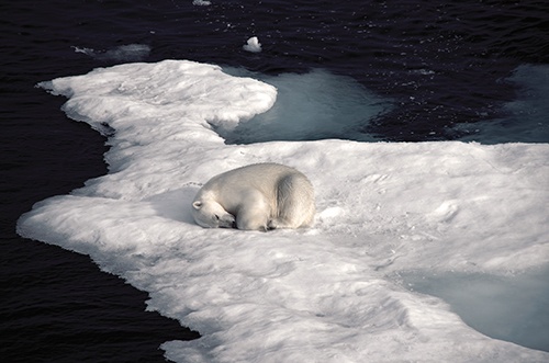
ON THE BRIDGE OF THE AKADEMIK IOFFE, I watched as we approached Prince Leopold Island at dawn. The island’s precipitous sandstone and limestone cliffs caught the dim light, rising out of a frigid, slushy sea like an enormous golden iceberg. I saw two polar bears: the large one made its way confidently from one floating island of ice to another, while a young female meandered along the beach under the imposing rocks, searching for a meal. Home to millions of breeding pairs of seabirds— mostly thick-billed murres, a relative of the puffin, as well as scores black-legged kittiwakes and the albatross-like northern fulmars—the island is one of the treasures of the proposed NMCA. It was where I saw my first bowhead whales the previous year, a mother and her calf feeding on tiny copepods. Their heads, the size of airport shuttles, gracefully rolled through the surface of the steely water.
That morning, however, the swarms of murres had mostly moved on. It was late in the season, and they had started their heroic migration east. With the chicks still flightless, the birds were forced to swim all the way to the North Water to survive the winter. It’s a three hundred kilometre journey through zero-degree ocean and ice floes, earned a few inches at a time. They weren’t the only animals making the migration. Belugas, narwhals, bowhead whales, walruses and harp seals were all on their way before the world froze around them, stranding them like Franklin’s ships.
The fortunate ones would survive the trip, dodging ships and .308 calibre bullets before reaching the promised land at the eastern end of Lancaster Sound. Their safe haven lies beyond the line that will someday be protected. But lines drawn on a map can only do so much.